|
This is Page 4 of 5 - the best of July 2010!
posted: July 31st, 2010 |
Go To Page:


|
On July 23rd, 24th and 25th Kazuya and I were in the Hakuba Area climbing Norikuradake (2,437 m = 7,994 ft), Mt. Korenge (2,766 m = 9,075 ft), Shiroumadake (2,932 m = 9,620 ft), Shakushidake (2,812 m = 9,226 ft) and Yarigatake (2,903 m = 9,525 ft). By the way ...dake and ...take = high peak. This page covers July 23rd only. Click on any thumbnail to begin.
|
 On Thursday night/Friday morning (July 22/23) we were on a night train to Hakuba. We arrived at Hakuba Station at 4:50 AM on July 23rd. We took a shared taxi to the Ropeway and rode up to its top and then transferred to a Gondola Car and rode up to the final destination. From there we started hiking at 7:40 AM. The first photo in this row was taken as we passed the Tsugaike Kogen Area at 7:53 AM. By the way, this Tsugaike Kogen is the same Tsugaike Kogen which we visited back in March of this year. You can refresh your memory HERE beginning in Row 11, if you so desire. The Tsugaike Kogen adventure back in March continues through Page 2 and Page 3 of that month's photos. The 2nd photo in this row was a new flower for us, it is Diphylleia cymosa ssp. grayi. The 3rd flower was also new for us, it is Kinugasa japonica aka Paris japonica. You may recall that you have seen Paris tetraphylla and Paris verticillata previously, this is another relative of those plants. This one is MUCH larger however - we were amazed.
|
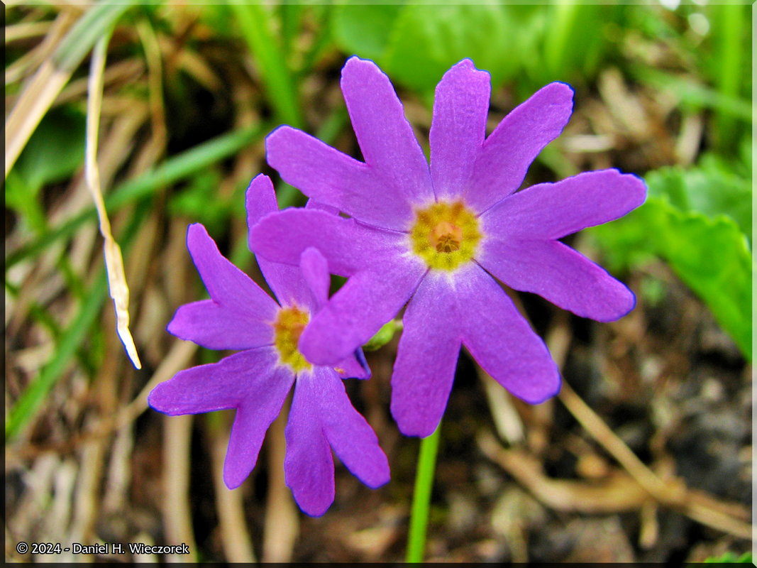
 Here is a closer shot of Kinugasa japonica aka Paris japonica in first position. It is followed by a shot of a Primrose (Primula sp.). The 3rd shot is a photo of a very high marshy area we passed through. I adjusted the Shadows and Highlights of this photo to make the Cottongrass stand out more prominently.
|
 The first shot in this row is a Heloniopsis orientalis. You may recall that we saw this plant last month at Oze National Park. Today we are at a much higher elevation and also further north, so it is still blooming here. The 2nd shot is the small high marshy area I referred to in the row above. The reflection of the snowfield is what makes this photo nice. In the 3rd shot, we have come to that snowfield shown in the 2nd photo.
|
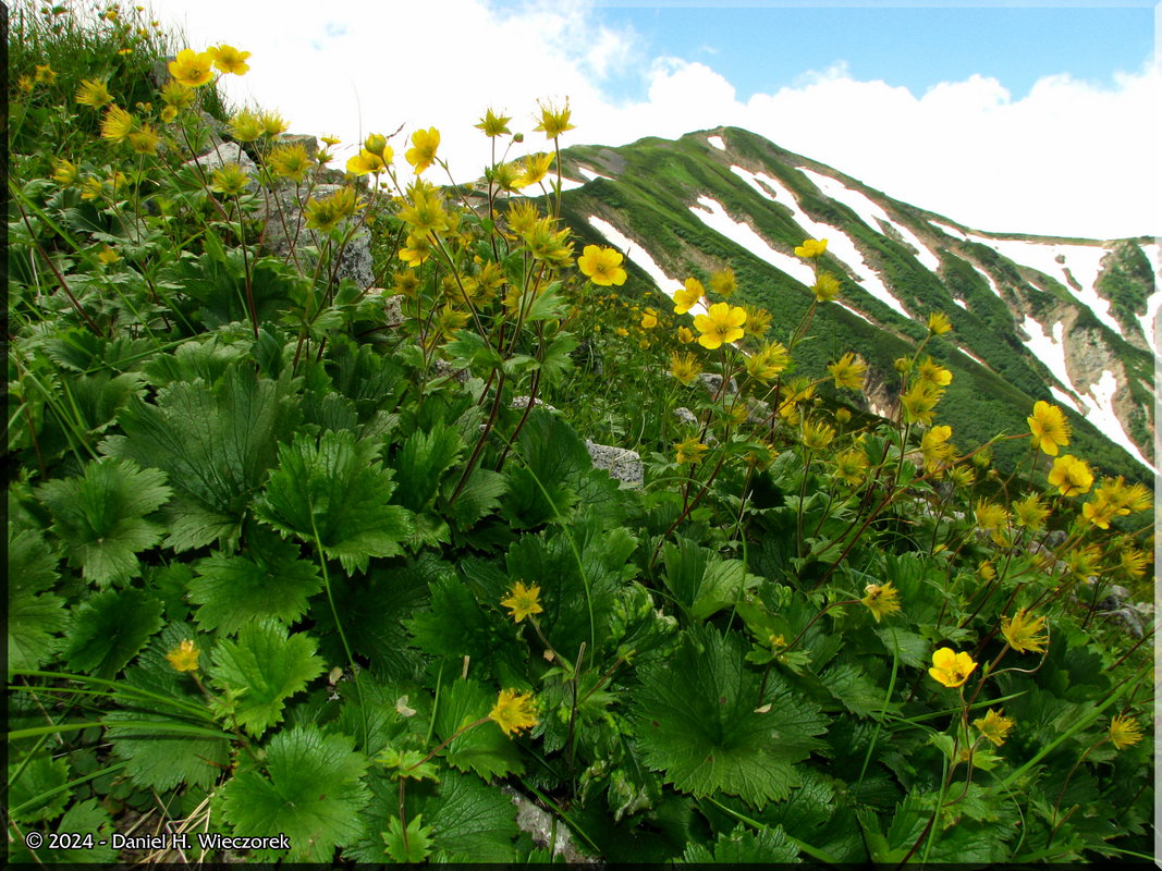
 Now it's around 10:00 AM and we are obviously much higher in elevation. The first shot here is a beautiful Rosa nipponensis. The 2nd shot is probably Ranunculus acris ssp. novus - against a beautiful blue sky background. The 3rd shot is Campanula dasyantha ssp. chamissonis - notice how hairy this flower is - the hairs make a very good identification feature.
|
 Now the time is around 10:30 AM and we are getting close to Hakuba Ooike, or Hakuba Big Pond. There is a Hut on the shore, as you can see, but this is NOT our destination for the day. This photo has been enhanced with Shadow Illuminator Pro, but that did not effect the beautiful water color, it just reduced the shadows in the foreground because the foreground was shaded by a cloud. The 2nd shot is the summit of Norikuradake (Mt. Norikura) (2,437 m = 7,994 ft). It doesn't seem like a mountain, it's more like just a high spot in the trail. The 3rd shot is 2 photos stitched together, it is obviously Hakuba Ooike (Hakuba Big Pond) again. This panorama was also enhanced with Shadow Illuminator Pro.
|
 Here is me standing at the sign which marks the Hakuba Big Pond (Hakuba Ooike). The 2nd and 3rd shots both show a beautiful patch of Geum pentapetalum.
|
 Here is another shot of that hairy Campanula - Campanula dasyantha ssp. chamissonis. The 2nd shot is a Dicentra peregrina - you may recall that this is one of my very favorite flowers. Later on you will see the best shot of it which I have ever taken. This shot is against a nice blue sky background. The 3rd shot is a very uncommon flower, it is Linnaea borealis. It has a circumpolar distribution in moist subarctic to cool temperate forests, extending further south at high altitudes in mountains, in Europe south to the Alps, in Asia south to northern Japan, and North America south to northern California and Arizona in the west, and Tennessee in the Appalachian Mountains in the east. It is known as Twinflower (sometimes written twin flower) in English.
|
 Here is an additional shot of Linnaea borealis (Twinflower). There were so many buds of this plant, but very few in bloom! The 2nd and 3rd shots are additional shots of Dicentra peregrina.
|
 Here is a final shot of Linnaea borealis (Twinflower) in first position. The 2nd shot may be Ranunculus acris ssp. novus - with a mountain scenery background. The 3rd shot is a Tone-mapped scenic image created from 3 bracketed exposures.
|
 In first position in this row is a non-hairy Campanula - Campanula lasiocarpa. In 2nd position is a very strange plant which we could not identify. In fact we are not sure if these brown things are the flowers or the seed heads. Anybody know what it is? In 3rd position is an amazingly beautiful Lily - Lilium medeoloides - against a blue sky background.
|
 Here is an additional Lilium medeoloides against a blue sky background. This shot has been enhanced with Shadow Illuminator Pro. The 2nd shot is a scenic shot as we get closer to Mt. Korenge. The 3rd shot is another scenic shot.
|
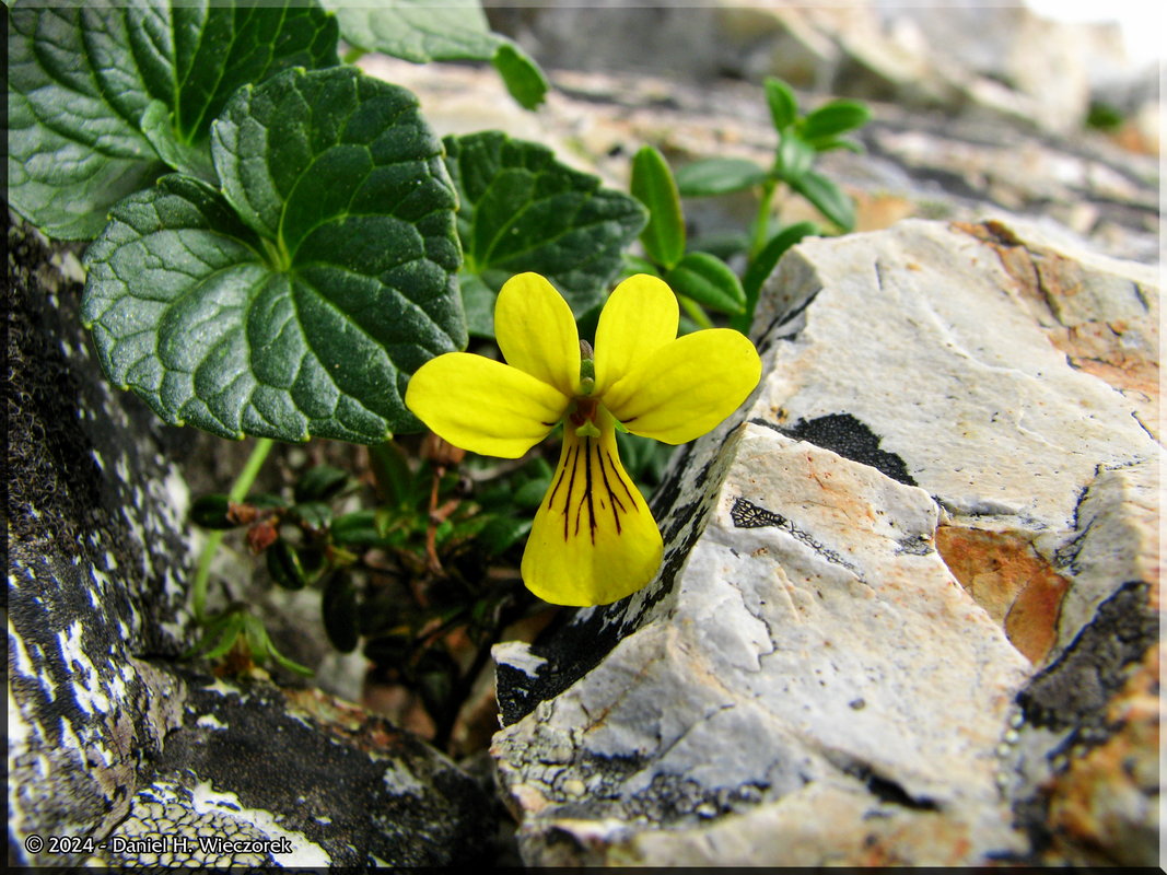
 We have gotten high enough again to be able to see back to Hakuba Big Pond (Hakuba Ooike) in this first shot. The time is now 1:38 PM. The 2nd shot is a pretty big snow field. This area has Japan's largest permanent snowfields. The 3rd shot is Viola crassa ssp. alpicola - a new violet for us!
|
 Here is the summit of Mt. Korenge (2,766 m = 9,075 ft)! We made it to the first semi-major mountain. The time is now 2:04 PM, we've been hiking for about 6 hours now. We stopped here to eat the lunch we brought with us and the 2nd photo shows me preparing to leave at 2:28 PM. The 3rd shot is an additional shot of Viola crassa ssp. alpicola. You will find a final shot of this Violet in the next row.
|
 Here is the final shot of Viola crassa ssp. alpicola. The 2nd shot is a very snowy scenic shot. The 3rd shot is that shot I mentioned above - the very best shot I have ever taken of Dicentra peregrina. It's also been enhanced with Shadow Illuminator Pro.
|
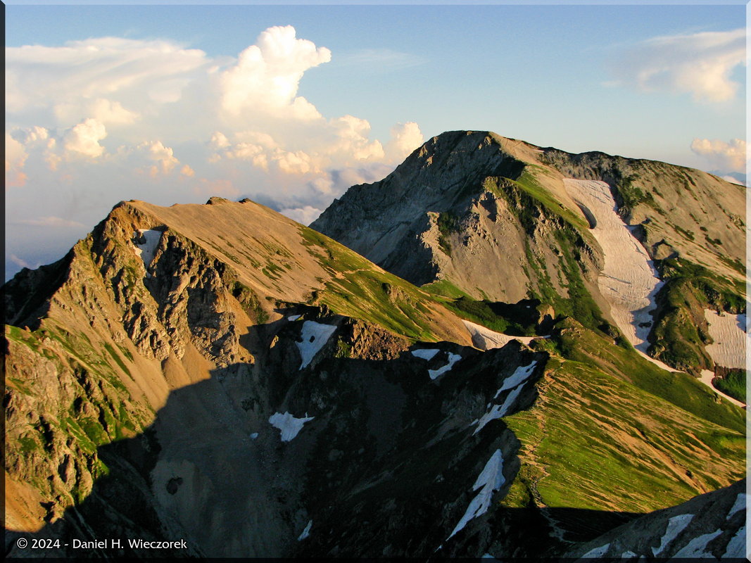
 In this row you see 3 scenic shots taken between Mt. Korenge and Shiroumadake. The time is getting to be around 3:15 PM.
|
 Way down off the trail we could see this pink color. We looked through our camera viewfinders and zoomed in and noted that there was a huge patch of Dicentra peregrina. They didn't want people leaving the trail, so we stayed where we were rather than going after it. Here is one faraway shot to give you an idea of what we saw anyway. The 2nd shot is an additional scenic shot. The 3rd photo here is a Lagotis glauca. There was lots of this flower, but it was mostly past its peak. There were still a few in bloom though.
|
 Here is one more Lagotis glauca photo in first position. The 2nd shot is a collage of "Brocken Spectre". It is actually only 2 photos - the top 2 photos are just as they came from the camera and the bottom 2 photos are the top 2 photos which have been enhanced by various Photoshop methods. We had only seen a Brocken Spectre once before and only for a brief time. That was at Mt. Yatsugatake and it was in July 2009. The 3rd shot is getting closer to Shiroumadake. This mountain had so many false peaks that it was shocking. We could keep seeing a peak off in the distance and we told ourselves "that must be the peak" and when we got there we could see another peak in front of us. The time is now 4:20 PM - we've been hiking over 8 hours.
|
 Ah, that next peak is surely the true peak of Shiroumadake - I can see the marker on it!! The 2nd shot is me at the summit of Shiroumadake (2,932 m = 9,620 ft). The 3rd shot shows some very brightly colored Pedicularis verticillata.
|
 Here is another shot of the Shiroumadake summit sign. The 2nd shot is our goal - the Shiroumadake Hut, we'll spend the night there. The 3rd shot is another shot of the summit monument. The time is 4:37 PM.
|
 Now it's around 6:30 PM. We have eaten our supper - it was served at 5:45 PM. It was pretty good food, especially considering that they don't give you any choices - everybody gets exactly the same thing. All supplies are flown in to here by helicopter. A beer will cost you 600 Yen (around $6 USD) - of course we had a beer each after supper. Anyway, I am getting sidetracked. We are now waiting for sunset and these photos all exhibit long shadows and some initial sunset colors. The first 2 shots show Shakushidake (2,812 m = 9,226 ft) - near - and Yarigatake (2,903 m = 9,525 ft) - far - mountains which we will climb tomorrow. The 3rd shot is a sea of clouds out over the Sea of Japan.
|
 In the 1st and 2nd photos you can see the moon and a huge thunderhead cloud. The 3rd shot shows the shadow of the mountain which we are on.
|
 The first shot in this row shows some good sunset color on that thunderhead cloud. The 2nd shot shows Tsurugidake (the tallest peak) and the Tateyama Mountains - we climbed over there last year in September 2009. The 3rd shot is once again, Shakushidake (2,812 m = 9,226 ft) - near - and Yarigatake (2,903 m = 9,525 ft) - far - mountains which we will climb tomorrow
|
 Here are 2 final sunset shots. That's all for this day. On the next page you can continue following this adventure, starting at 6:14 AM July 24th.
|
| End Page 4, End July 23rd
|
|
Thank you for taking the time to look at this page. There is one more page this month. If you go to page 5 you will see the conclusion of this adventure to the Hakuba Area (there are still 2 more days) and also the conclusion of July.
|
Go To Page:
|

Link to Amazon.com (new window).
We get 2% of whatever you spend if you go to Amazon from this link!! Please shop on Amazon from here.
|
If you would like to donate to our hiking & traveling fund or show your appreciation for our efforts you can donate through PayPal. A single donation will entitle you to request a single full-sized photo IN THE DONATION MONTH - which you may then use as a desktop wallpaper or whatever. The copyright will be retained by us and the photo will be inconspicuously marked with the copyright symbol (©), year and photographer's name. (Donation probably not tax deductible.)
|
|