posted: August 1st, 2017 |
Go To Page: |
This page continues July 8th at 6:40 PM, as stated on Page 2.  We finish July 8th in Row 3 and then we show a few photos from our trip home on July 9th - including an Arctic Grayling (Thymallus arcticus) that Kazuya caught in the Chatanika River.  In Row 6 we begin an adventure which saw us drive up the Elliott Highway to its junction with the Dalton Highway and then drive 6 miles up the Dalton Highway. This page, however, ends with a hike to Lower Grapefruit Rocks, at Milepost 39.3 of the Elliott Highway.  The adventure continues and concludes on Page 4.  Click on any thumbnail to begin.
|
July 8th Continues from Page 2 (at 6:40 PM) |
  When we left the Table Top Mountain Trailhead, we continued on the same road for another 5 miles or so, to the end of it, and Ophir Creek Campground, maintained by the BLM. We camped here in our pickup canopy. The second and third shots show the rock that was visible in the Center Photo, Row #8, Page 2. It's much closer now! The third shot is a more zoomed-in shot of that rock. |
July8th_318_ OphirCreekCampgroundRC |
Jul8_166_Ophir CreekCampgroundRC |
Jul8_167_Ophir CreekCampgroundRC |
  The first photo is looking back at Table Top Mountain and the outlined area shows the next photo, Table Top Mountain, both upper and lower, |
Jul8_172_Ophir CreekCampgroundRC |
Jul8_175_Ophir CreekCampgroundRC |
  Here is a final shot of the rock that was visible in the Center Photo, Row #8, Page 2 and then a shot of Kazuya walking across the hummocks in the muskeg. We did some Arctic Grayling fishing in Ophir Creek and we caught some, but this is a catch and release area, so we quickly released the two fish that we caught and did not stop to take any photos. The next morning it was raining a little bit, but not enough to really bother us much. We drove back to the Steese Highway and on the way, we stopped to take some shots of this Epilobium latifolium - Dwarf Fireweed - alongside of Nome Creek. |
Jul8_178_Ophir CreekCampgroundRC |
Jul8_185_Ophir CreekCampgroundRC |
End July 8th, Begin July 9th |
  Here is a final shot of the rock that was visible in the Center Photo, Row #8, Page 2 and then a shot of Kazuya walking across the hummocks in the muskeg. We did some Arctic Grayling fishing in Ophir Creek and we caught some, but this is a catch and release area, so we quickly released the two fish that we caught and did not stop to take any photos. The next morning it was raining a little bit, but not enough to really bother us much. We drove back to the Steese Highway and on the way, we stopped to take some shots of this Epilobium latifolium - Dwarf Fireweed - alongside of Nome Creek. |
Jul9_02_Dwarf Fireweed_NomeCreekRC |
July9th_001_NomeCreek Valley_EpilobiumLatifoliumRC |
July9th_003_NomeCreek Valley_EpilobiumLatifoliumRC |
  We stopped at a spot alongside the Chatanika River on our way home and did more Arctic Grayling (Thymallus arcticus) fishing. We each caught one, but the one I caught got away while we were trying to get it into the plastic shopping bag that we were using as a net! Note that we have bought a real fish net since that time. Here are two shots of the one Kazuya caught. This was fried in butter and lovingly prepared by Kazuya - it was absolutely delicious.
|
Jul9_13_ KazuyasGraylingRC |
July9th_020_ ArcticGraylingRC |
End July 9th, Begin July 18th |
  On July 18th we took a trip up the Elliott Highway. We made a stop at Lower Grapefruit Rocks, the trailhead for which, is at milepost 39.3. We've been to Upper Grapefruit Rocks a few times, but we'd never hiked out to Lower Grapefruit Rocks. The first photo in this row shows Shepherdia canadensis (Soapberry). We've rarely seen this plant. The second photo shows Delphinium glaucum and the third photo shows Kazuya at Lower Grapefruit Rocks. The trail coming in to here is very muddy, so we wore rubber boots.
|
July18th_002 _ElliottHwyRC |
July18th_001 _ElliottHwyRC |
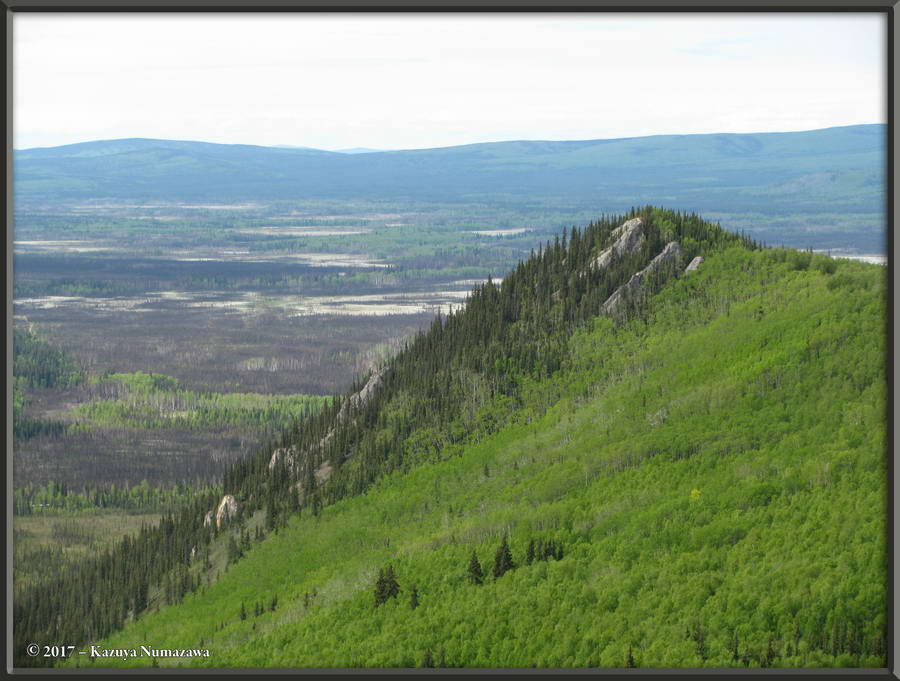
July18_01_Lower GrapefruitRocksRC |
  The first photo in this row is a scenic shot in which you can easily see the TAPS (Trans-Alaska Pipeline System). The second photo is looking towards Upper Grapefruit Rocks - they are on that mountain just to the left of center. The third image is a 3-exposure Tone-mapped shot of Upper Grapefruit Rocks. Due to the lighting you cannot see Upper Grapefruit Rocks at all. |
July18th_003 _ElliottHwyRC |
July18th_004 _ElliottHwyRC |
July18_05_06_07_TMDE_ LowerGrapefruitRocksRC |
  In this zoomed-in shot (3-exposures, Tone-mapped using the Tone Compressor option) you can kind of pick out the various Upper Grapefruit Rocks. The second shot is another scenery one and the third shot again shows Shepherdia canadensis (Soapberry). Yes, they do taste pretty terrible. |
July18_08_09_10_TMTC_ LowerGrapefruitRocksRC |
July18_13_Lower GrapefruitRocksRC |
July18_18_LowerGrapefruit Rocks_Shepherdia_canadensisRC |
  Here are two more shots of Delphinium glaucum and then a shot of one of the Lower Grapefruit Rocks. |
July18th_013 _ElliottHwyRC |
July18th_012 _ElliottHwyRC |
July18_19_Lower GrapefruitRocksRC |
  Here is another shot of one of the Lower Grapefruit Rocks in first position. The second and third photos were taken on May 29th and I am including them here to show what Lower Grapefruit Rocks looks like from Upper Grapefruit Rocks. |
July18_20_Lower GrapefruitRocksRC |
May29_95_ GrapefruitRocksAreaRC |
May29th_206_ GrapefruitRocksRC |
End Page 3, but July 18th continues on Page 4 (at 10:07 AM) |
(will open in new window) |
If you would like to donate to our hiking & traveling fund or show your appreciation for our efforts you can donate through PayPal. A single donation will entitle you to request a single full-sized photo IN THE DONATION MONTH - which you may then use as a desktop wallpaper or whatever. The copyright will be retained by us and the photo will be inconspicuously marked with the copyright symbol (©), year and photographer's name. (Donation probably not tax deductible.) |