|
This is Page 1 of 3 - the best of December 2011!
posted: December 28th, 2011 |
Go To Page:


|
This page includes only photos taken on December 4th. Kazuya and I went out to Mt. Takao on that date and found enough photogenic items, mostly autumn (fall) colors, to fill this page. Click on any thumbnail to begin.
|
 Here are 3 Autumn Color photos which we took as we walked from the Takao San Guchi train station up to the start of the trails which take one to the summit of Mt. Takao. Can you recall the elevation of Mt. Takao from previous month's climbs of this mountain? It is 599 meters or 1,965 feet.
|
 The photos in this row - also Autumn Color photos - were all taken at the area where all of the summit trails (6 different ones) begin. The center photo is a Tone-mapped image of 3-exposure bracketed photos. It was created using Photomatix Pro Software and the Details Enhancer Option.
|
 Now we are climbing the mountain. The first photo was taken from a bend in the trail where it was possible to overlook the opposite ridge. The 2nd and 3rd photos were taken from an overlook higher up the mountain. The 2nd photo shows an overview of metropolitan Tokyo while the 3rd shot shows a zoomed in shot featuring "Tokyo Sky Tree". The Tokyo Sky Tree is a broadcasting, restaurant and observation tower under construction in Sumida, Tokyo, Japan. When completed (in early 2012), the tower will have a height of 634.0 meters (=2,080 ft). One of Tokyo Sky Tree's main purposes will be as a television and radio broadcasting tower. Tokyo's current broadcasting tower, Tokyo Tower, is at 333 m (=1,093 ft), no longer tall enough to give complete digital terrestrial television broadcasting coverage as it is surrounded by many high-rise buildings. When completed, the Tokyo Sky Tree will be the tallest tower in the world beating Canton Tower (600 m = 1,969 ft), the tallest structure on an island, beating Taipei 101 and the second tallest structure in the world, after the Burj Khalifa. (Thanks to Wikipedia for above information.) The 3rd photo shows Sky Tree towering over everything else in the city.
|
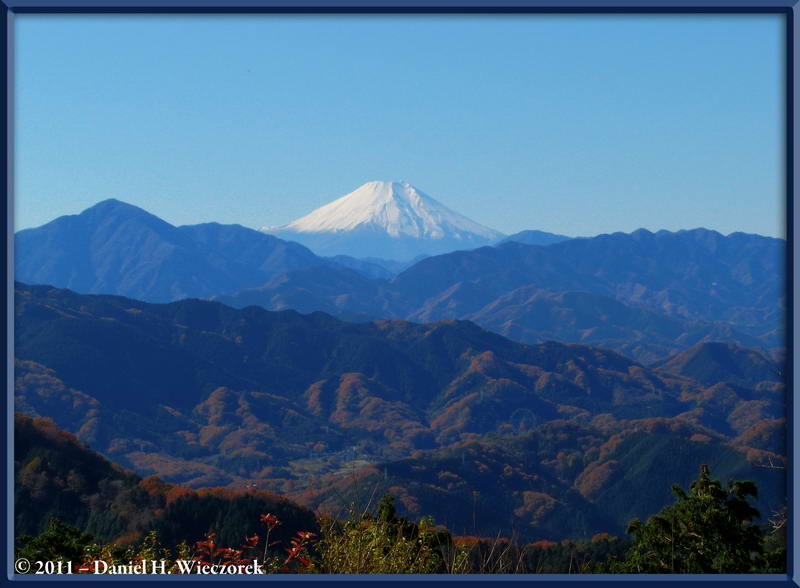
 Here are 3 shots which show Mt. Fuji. The first shot was taken along the trail and the next 2 images were taken from the summit of Mt. Takao. The 2nd image was created with Photomatix Pro software using 3 exposure-bracketed images and the Tone Compressor Option.
|
 In first position in this row is an additional shot of Mt. Fuji from the summit of Mt. Takao. That is followed by a shot of Enoshima Island and the Pacific Ocean - a rare sight from Mt. Takao. This was an amazingly clear day. The 3rd shot shows the "Chip Star" display at the summit of Mt. Takao - note that these are the small sized packages and that they are selling them for ¥170. Just a bit high priced I would say, seeing as they can be purchased at a convenience store for ¥110 - and there is a road to the top of Mt. Takao, so it does not cost that much to transport them here. All foods and drinks are a rip-off here!
|
 Now we are hiking from Mt. Takao towards Mt. Kobotoke-Shiro (670 meters = 2,199 feet). This is around the Momiji-Dai area. Here you can see people along the trail and fall colors.
|
 Now we are getting to the I-Ccho-Daira Area - more autumn colors.
|
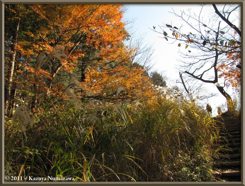
 The first shot in this row was taken close to I-Ccho-Daira - some nice lighting on the Susuki Grass (Miscanthus sinensis). The 2nd shot shows a new Tengu (the Long-Nosed god) wooden chain-saw sculpture at the summit of Mt. Kobotoke-Shiro. The 3rd shot is one of the Greater Metropolitan Tokyo Area from this location.
|
 Here is a shot from this location where I have zoomed-in to Tokyo Sky Tree. Then we hiked down the Hikage Creek Trail and we found several Violets in bloom - Global Warming is causing havoc for the flowers in this area - winter flowers and spring flowers are getting confused about when they should bloom! This one is a Viola japonica. The 3rd shot is a final autumn color shot from this trip - this was, of course, along the Hikage Creek Trail.
|
| End December 4th, End Page 1
|
|
Thanks so much for taking the time to look at this page. Now, please go on to Page 2 for the continuation of this month's adventures.
|
Go To Page:
|

(will open in new window)
|

(will open in new window)
[PASSWORD PROTECTED]
|

Link to Amazon.com (new window).
We get 2% of whatever you spend if you go to Amazon from this link!! Please shop on Amazon from here.
|
If you would like to donate to our hiking & traveling fund or show your appreciation for our efforts you can donate through PayPal. A single donation will entitle you to request a single full-sized photo IN THE DONATION MONTH - which you may then use as a desktop wallpaper or whatever. The copyright will be retained by us and the photo will be inconspicuously marked with the copyright symbol (©), year and photographer's name. (Donation probably not tax deductible.)
|
|