|
This is Page 1 of 4 - the best of August 2010!
posted: August 31st, 2010 |
Go To Page:


|
This page begins with August 1st - a trip to Mt. Mitake, and takes you through the 8th of August. We started our vacation to Hokkaido - The Alaska of Japan - in Daisetsuzan National Park, on August 6th, so photos of the 6th, 7th and 8th were taken while we were on vacation. Click on any thumbnail to begin.
|
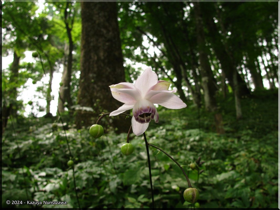
 On August 1st Kazuya and I went out to Mt. Mitake to check out the flowers of Rengeshouma (Anemonopsis macrophylla). We knew it would be early for the peak of blooming, but we felt that it might be our best opportunity, considering other plans for August. We found the Rengeshouma flowers, not in abundance, but enough to photograph. We also found beautiful Mountain Lilies (Lilium auratum) - which have the most amazing scent! Okay - the first shot is the Mountain Lily, the 2nd shot, out of chronological order, but put in center position for balance, shows the twin of the Cable Car which we used to come to the mountain top. The one in the photo is going down as we go up. The 3rd shot is a Rengeshouma.
|
 Here are 3 additional Rengeshouma (Anemonopsis macrophylla) flowers. You can find additional photos of this flower just about every year in the August pages if you are interested. There are also some collages; go to the homepage and in the Google search box type "rengeshouma collage" (without quotes) and hit the enter key.
|
 Here is a Jack-in-the-Pulpit (Arisaema sp.) seed-head with a couple of Rengeshouma buds behind it for scale. In 2nd position is a shot of some more Mountain Lilies. The 3rd shot is additional Rengeshouma flowers.
|
 After we finished on the Mountain we took the Cable Car back to the bottom and bought some beer and snacks at the new 7-Eleven Convenience Store near Mitake Station. Then we went down to the river and drank our beer in the shade while soaking our feet in the cool river. We enjoy doing that one or 2 times during the hot summer. And, that's the end of the Mitake Trip on August 1st.
|
| End August 1st, Begin August 6th - Vacation
|
 On the night of August 5th I got home from work at 10:00 PM and after changing my clothes and donning my backpack (Kazuya got home earlier than I did and he was all ready) we immediately left for the train station, took a train to Shinjuku and then boarded a night train (The Moonlight Echigo) and rode all night. We debarked at Niitsu Station. The first picture, Niitsu Station, was taken at 4:47 AM. From there we took a train bound for Sakata (the train in the 2nd photo) and from there to Aomori Station. We finally arrived at Aomori Station at 5:10 PM. We put our bags on the platform where our next train was to depart from and wandered around Aomori City, ate supper and so on. The 3rd photo is a float for the Annual Nebuta Festival - a Festival for which the whole town turns out it seems.
|
 Here are 2 additional photos taken at the Aomori Nebuta Festival. The 3rd photo is the train we rode from Aomori to Sapporo. We left Aomori on this train at 10:42 PM on August 6th and got off at Sapporo Station on Hokkaido at 6:07 AM on August 7th.
|
| End August 6th, Begin August 7th - Vacation
|
 The first photo here is Sapporo Station - we arrived, as I said above - at 6:07 AM on August 7th. We ate breakfast in Sapporo and then took an Express Train to Kamikawa at 7:21 AM and arrived there at 9:41 AM. We took a bus from there at 9:50 AM and got off at Souunkyou Bus Stop at 10:20 AM (2nd photo). After about 36 hours of travel we wanted nothing more than to get cleaned up! It was fortunate that Souunkyou is a Hot Spring area, so we had no trouble at all finding a Hot Spring. We got cleaned up, changed our clothes, ate a brunch and then started up the mountain. The 3rd photo shows the view from the Ropeway - it had started to rain just before we got off the train at Kamikawa.
|
 Now in Daisetsuzan National Park. Can you recall this name? We came here for part of our August vacation last year too. You can find the photos taken in this National Park last year HERE. The first photo in this row is at the top of the Ropeway. From here we had to take a lift (2nd Photo). From the top of the lift we started hiking (around 1:15 PM). It was raining pretty heavy and we could not see very far. We were in our rain gear and although it was far from hot, we were still sweating inside of the rain gear. We arrived at the summit of Mt. Kuro (Kurodake) (1,984 meters = 6,509 feet) at about 2:55 PM. If you would like to attempt to follow our wanderings over the mountains of Daisetsuzan National Park over the course of 4 days there is a map HERE. It will open in separate window. This map can also be found on Page 3 at the bottom.
|
 We started down the opposite side of Mt. Kuro after a few minutes and from there it was only about 45 minutes to the hut. Our goal for the first day was a modest one - to get to the hut! We knew we'd be exhausted from 36 hours of travel and we didn't want to push ourselves. There is enough to see near the hut so that we didn't need to go any further. In the first photo in this row you can actually see the hut - our destination - if you study for a bit (just barely to the right of center). We crossed a small valley and discovered that it was filled with these Phyllodoce caerulea var. yezoensis plants/flowers so we stopped there for a while and took photos. You can also note that there is still snow in this valley.
|
 Here is a close shot of Phyllodoce caerulea var. yezoensis flowers. The 2nd shot is Geum pentapetalum. We arrived at the hut and it was - fortunately - not crowded. We had plenty of space to spread out and dry out. We rented sleeping bags in advance by telephone as they only had 50 of them. This hut offers a place to sleep and electric lights in the evening, but they offer no meals. We had to take our cook stove and gas and food with us. They have beer and soft drinks too. We had a visitor shortly after we got settled in - this chipmunk. As we slowed down we cooled off and actually got quite cold. We spent some time curled up in our sleeping bags warming up - as did most people - before we started preparing our supper.
|
 After supper it actually stopped raining and we had decent visibility for a while. The first photo here shows a mountain right beside the hut. Supposedly it was only 10 minutes from the hut to the summit of this mountain, but we didn't test the time. The 2nd shot shows the hut itself. (Map HERE)
|
 We took advantage of the lack of rain to hike around the hut a bit and see the scenery. We really wondered what creates the weird green valleys seen in the 2nd photo. This valley can be seen in the first photo - near the left edge.
|
| End August 7th, Begin August 8th - Vacation
|
 The next day - August 8th - it continued to be cloudy and rain intermittently. We slept in until 7:00 AM and then cooked our breakfast and got ready and started hiking at about 8:00 AM. Our goal today was to entail about 8 hours of hiking. We intended to hike to and climb Mt. Hokkai (Hokkaidake) (2,149 m = 7,051 ft) and then hike to and climb Mt. Hakuun (Hakuundake) (2,229.5 m = 7,315 ft). From there we would return to the Mt. Kuro (Kurodake) Hut. We would have to cross over the top of Mt. Hokkai (Hokkaidake) twice - once on the way to Mt. Hakuun and once on the way back to the hut. The first photo here is a Gentiana nipponica with a Geum pentapetalum behind it. The 2nd photo is Kazuya crossing the river! We call this "Poison Hot Spring Valley River". It flows out of the "Valley of the Poison Hot Spring". You'll see this designation many times, so please remember this river and this term. The 3rd photo is one of several snow fields - steam rises from this one. By the way, we accomplished everything we hoped to accomplish this day. (Map HERE)
|
 The first photo here shows Mt. Kuro (Kurodake) on the left side. The 2nd photo is a scenic shot and the 3rd shot was taken when it cleared for a moment and we could see the summit of Mt. Hokkai (Hokkaidake) - our first goal for today.
|
 Here is me in first position - with a nice scenic background. The 2nd shot is a panorama - Mt. Kuro (Kurodake) is the center mountain in this photo. The 3rd shot is a weird rock formation.
|
 Here is a Penstemon frutescens in first position. The 2nd shot is Kazuya with a nice scenic background. The 3rd shot is a scenic photo - looking back down the slope of Mt. Hokkai (Hokkaidake) and showing some people behind us.
|
 Here is a beautiful blue Gentiana nipponica flower in 1st position. The 2nd shot shows Kazuya and I at the summit of Mt. Hokkai (Hokkaidake (2,149 meters = 7,051 feet). It's windier than you want to think about, which is why I am holding on to my hood. The 3rd shot is some kind of Thistle - this was taken as we descended Mt. Hokkai (Hokkaidake) on our way to Mt. Hakuun (Hakuundake). (Map HERE)
|
 Here is that same kind of Thistle again. The 2nd shot is kind of a miniature world on a hummock. The 3rd shot is another type of Gentiana - this one is Gentiana algida f. igarasii and it is found only here in Daisetsuzan National Park.
|
 Here is another shot of Gentiana algida f. igarasii. It is followed by a scenic shot showing what appears to be a very deep snow drift! The 3rd shot is me crossing a snowfield (not the snowfield in the previous photo). This one was easy - the snow was soft and it was easy to dig in with our boots.
|
 Here is a shot looking back at that snowfield we just crossed. You can see a tiny human figure crossing it - this gives you an idea of the scale of things. The 2nd photo is a very strange flower, a Bryanthus gmelinii. The 3rd photo shows Kazuya and I at the summit of Mt. Hakuun (Hakuundake (2,229.5 meters = 7,315 feet). It was blowing so dang hard here that we had to find shelter behind a big rock to be able to eat our lunch at 12:15 PM. It never cleared up while we were here, so we never had a good view of anything from this summit. Again, I invite you to follow our journeys on the map HERE.
|
 From Mt. Hakuun (Hakuundake) we headed back towards the Kurodake Hut. We had to cross back over Mt. Hokkai (Hokkaidake) to get there. On the slope going back up Mt. Hokkai (Hokkaidake) Kazuya noticed a fox. It was not fearful of us at all and although it never came very close, it allowed us to take as many photos as we wanted to, using the zoom feature of our cameras. The photo of Kazuya on the snow should be in 3rd position chronologically, but I put it in second position for balance. We arrived back at the hut at just about 4:00 PM and immediately we bought and drank a can of beer! We cooked and ate our supper after a while and went to bed at around 8:00 PM. The next day was to be a long one!
|
| End August 8th, End Page 1
|
|
Thanks so much for taking the time to look at this page. Now, please continue on to Page 2 for the continuation of this adventure to Hokkaido - The Alaska of Japan. The next page begins on August 9th at 7:22 AM.
|
Go To Page:
|

Link to Amazon.com (new window).
We get 2% of whatever you spend if you go to Amazon from this link!! Please shop on Amazon from here.
|
If you would like to donate to our hiking & traveling fund or show your appreciation for our efforts you can donate through PayPal. A single donation will entitle you to request a single full-sized photo IN THE DONATION MONTH - which you may then use as a desktop wallpaper or whatever. The copyright will be retained by us and the photo will be inconspicuously marked with the copyright symbol (©), year and photographer's name. (Donation probably not tax deductible.)
|
|